
Typhoon Bavi Threatens Taiwan and China as Philippine Deaths Rise
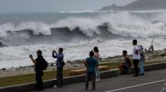
Typhoon Bavi Intensifies: A Regional Weather Crisis Unfolds
East Asia is facing an unprecedented weather emergency as Typhoon Bavi, an enormous tropical cyclone spanning approximately 1,000 kilometers in width, moves toward the region. Typhoon Bavi represents one of the most formidable atmospheric systems forecasted to impact the area in several decades, prompting urgent preparations across multiple nations. The storm's trajectory places Taiwan and southeastern China directly in its path, with authorities implementing comprehensive contingency measures to protect populations and infrastructure.
Philippine Casualties Mount Amid Pre-Storm Conditions
The Philippines has already experienced devastating consequences from weather-related disasters preceding Typhoon Bavi's arrival. Landslides triggered by heavy precipitation have resulted in 15 confirmed fatalities, with rescue operations ongoing throughout affected communities. These casualties underscore the extreme hazards posed by the approaching typhoon and serve as a stark reminder of the destructive potential inherent in major tropical cyclone systems. Local authorities have intensified search and rescue missions while simultaneously preparing evacuation protocols for vulnerable populations.
Taiwan Prepares for Maximum Impact
Taiwan stands directly in Typhoon Bavi's projected path, making the island nation particularly vulnerable to the storm's most severe effects. Government agencies have activated emergency response protocols, issuing typhoon warnings and implementing coastal evacuations in high-risk zones. The island's weather services are monitoring the system's development continuously, issuing updated forecasts every few hours as the storm approaches. Residents in exposed areas have been advised to secure property, stock essential supplies, and prepare shelters in anticipation of potentially catastrophic winds and flooding.
Southeast China Mobilizes Defensive Measures
Chinese authorities in southeastern provinces are implementing large-scale preparedness initiatives ahead of Typhoon Bavi's expected arrival. Provincial governments have mobilized emergency response teams, positioned disaster relief supplies, and established communication networks to coordinate rapid deployment of assistance if required. The potential impact on this densely populated region has prompted officials to consider temporary closures of transportation networks, suspension of industrial operations in vulnerable sectors, and activation of sheltering facilities in municipalities expected to experience the storm's direct effects.
Historical Context: Decades-Long Storm Intensity
Meteorological analysts have classified Typhoon Bavi as potentially one of the most powerful typhoons to impact East Asia in multiple decades. This categorization reflects both the system's current intensity measurements and forecast models projecting minimal weakening before landfall. Historical precedent suggests that storms of comparable magnitude have inflicted substantial infrastructure damage, triggered widespread flooding, and caused significant casualties across affected regions. The combination of Typhoon Bavi's enormous spatial dimensions and predicted strength creates conditions for potentially catastrophic regional impact.
Regional Response and International Cooperation
Multiple nations across East Asia are coordinating preparedness efforts through established disaster management channels. International meteorological organizations are providing technical support and enhanced monitoring capabilities to national weather services throughout the region. Countries affected by Typhoon Bavi's projected path are sharing real-time data and forecasting information to ensure coordinated emergency responses. This collaborative approach reflects recognition that major tropical cyclone systems transcend political boundaries and require comprehensive multinational coordination for effective disaster mitigation.
Critical Weather Monitoring Continues
Meteorological agencies maintain continuous surveillance of Typhoon Bavi's development and movement patterns. Advanced satellite technology and computer modeling systems provide increasingly precise forecasts as the storm approaches populated areas. Updated advisories are being disseminated regularly to emergency management officials, media organizations, and the general public throughout the region. These forecasting improvements enable more accurate evacuation timing and targeted deployment of emergency resources to areas facing greatest risk from Typhoon Bavi's passage.